|
Below, you will find a little more
information about each of these magnificent salmon and steelhead fishing streams.
Sol
Duc River
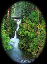
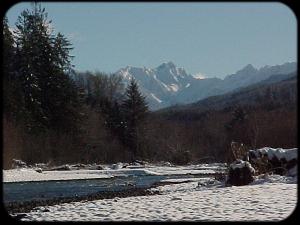
Perhaps the best known of the area's
rivers, the Sol Duc (Quileute for "sparkling water') begins in the Seven Lakes Basin
in Olympic National Park and surges downstream amid it's countless boulderfields to its
confluence with the Bogachiel River ( the combined rivers become known as the Quillayute
).
 The river has a long angling history and
has several famous fly patterns named after it that were originally tied by flyfishing
legend Syd Glasso who lived and taught in the town of Forks for some time. The river has a long angling history and
has several famous fly patterns named after it that were originally tied by flyfishing
legend Syd Glasso who lived and taught in the town of Forks for some time.
We probably spend more fishing days on
this river than any other over the course of the year due in part to the river's ability
to stay in good fishing shape even after a fairly heavy rain.
The river, especially the uppermost
drifts, have relatively steep gradients and provide anglers with a fun ride down the river
even on the days when the fishing isn't the best.
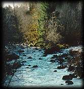
Calawah
River
 The main river begins just four or five
miles east of Forks where it's two forks (the North and South, of course!) join and it
dumps into the Bogachiel about three miles west of town just below the steelhead hatchery
on the Bogachiel. The main river begins just four or five
miles east of Forks where it's two forks (the North and South, of course!) join and it
dumps into the Bogachiel about three miles west of town just below the steelhead hatchery
on the Bogachiel.
The river receives light fishing
pressure to due to it's relatively poor bank access and the nearly constant class II and
III rapids that make navigating the river dangerous for oarsmen not familiar with the
rivers many splits and drops.
For decades, the river was the last
one to go out of fishing shape and the first to come back in following a heavy winter
rain. This changed, however with the emergence of some large slides that formed on it's
South Fork during the '97 flood. These slides now appear to be stabilizing.
Although salmon and steelhead do not
return to this river in especially large numbers, those that do are often quite large.
Many 30+ pound steelhead have been caught in its waters and rumor has it that a state
biologist, doing a king salmon spawning survey years ago, found a king carcass with the
fish's estimated weight (upon entering fresh water) at over 110 pounds!!
South
Fork Calawah
The river is only open from Hyas Creek
down (maybe four miles above the forks) until the end of
February. Therefore it is only fishable for a short amount of time each year (after the
arrival of the wild steelhead).
Seemingly just a creek in some areas,
this is usually the first place we go after a high water but the unstable slides high
upstream often change these plans. The river is filled with smaller pockets and runs that
make it a superb hardware or fly fishing option.
The numbers of fish are small, but
it's splendid beauty and just enough fish to keep a few rods bending make it an excellent
experience. The last stretch above the forks is known as "Hell's Half Mile" with
a long, continuous stretch of class III rapids followed by a III+ final drop that will
take any driftboater's breath away!
 A note
to would be boaters not familiar with these waters ... warning signs on the Calawah and Sol Duc were NOT put there by
guides trying to keep you away ... the water is dangerous and the remnants of destroyed driftboats left in the river are a testament to this fact! A note
to would be boaters not familiar with these waters ... warning signs on the Calawah and Sol Duc were NOT put there by
guides trying to keep you away ... the water is dangerous and the remnants of destroyed driftboats left in the river are a testament to this fact!
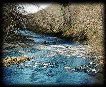
Bogachiel
River
Beginning on the southwestern flank of
Bogachiel Peak in Olympic National Park's High Divide, the river lays mostly within the
park boundary.
The river is best known amongst
anglers for it's large run of hatchery origin steelhead yet some of the largest steelhead
to return to any Peninsula stream return to the upper reaches of this river.
The upper reaches of the rivers
boatable water is characterized by small "rock gardens" nestled between some of
the finest fly fishing water on the Peninsula.
As you near the river's confluence
with the Sol Duc, the river's gradient becomes flatter and often forms long slow pools
that leave driftboaters wishing they had outboards.
Hoh
River
Often changing its course by hundreds
of yards after a heavy rain, the shifts in the riverbed are only part of this river's
multi-faceted character.
From the National Park boundary (the
uppermost launch) downstream, most of the river meanders through ancient glacial deposits
and often enormous log jams through most of it's length. Then, just ten miles from the
ocean, the river abruptly drops into a a small canyon cut out of bedrock.
Through the "canyon",
layered rock deposits point upward nearly vertically showing evidence of the strong
tectonic forces that created the Olympic Peninsula millions of years ago.
These rock walls rise abruptly,
covered with moss and some towering spruce, fir, and hemlock that
were already here for centuries before the arrival of the white settlers. Small waterfalls
running off the canyon walls into the river are about the only noise you'll hear other
than the occasional call of a bald eagle or the drumming of a male grouse. towering spruce, fir, and hemlock that
were already here for centuries before the arrival of the white settlers. Small waterfalls
running off the canyon walls into the river are about the only noise you'll hear other
than the occasional call of a bald eagle or the drumming of a male grouse.
The "canyon" stretch lasts
about two miles, then, just as suddenly as we drop into it, we re-emerge into the broad
valleys of the lower river.
The upper
portion of the Hoh is our 'home' water. Generally if the river is at all
fishable, we're fishing it unless you request otherwise. Five years ago,
the State of Washington made this stretch a mandatory catch-and-release
area for wild steelhead.
|

 The South Fork of the Calawah is the
least fished floatable (only by VERY experienced oarsmen familiar with the river)
piece of water around the Forks area.
The South Fork of the Calawah is the
least fished floatable (only by VERY experienced oarsmen familiar with the river)
piece of water around the Forks area.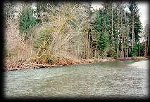 fishable length, the "bunny hill" of the region's rivers.
 Mother Nature's version of Dr. Jeckyl / Mr. Hyde.